
Αρχείο:Magyarorszag 1920.png

Μέγεθος αυτής της προεπισκόπησης: 800 × 543 εικονοστοιχεία . Άλλες αναλύσεις: 320 × 217 εικονοστοιχεία | 640 × 435 εικονοστοιχεία | 1.024 × 695 εικονοστοιχεία | 1.140 × 774 εικονοστοιχεία.
Εικόνα σε υψηλότερη ανάλυση (1.140 × 774 εικονοστοιχεία, μέγεθος αρχείου: 188 KB, τύπος MIME: image/png)
|
|
Αυτό το αρχείο και η περιγραφή του προέρχονται από το Wikimedia Commons. Οι πληροφορίες από την σελίδα περιγραφής του εκεί εμφανίζονται παρακάτω. |

|
This linguistic map image could be re-created using vector graphics as an SVG file. This has several advantages; see Commons:Media for cleanup for more information. If an SVG form of this image is available, please upload it and afterwards replace this template with
{{vector version available|new image name}}.
It is recommended to name the SVG file “Magyarorszag 1920.svg”—then the template Vector version available (or Vva) does not need the new image name parameter. |
Σύνοψη
| Περιγραφή |
Беларуская (тарашкевіца): Трыянонская мірная дамова
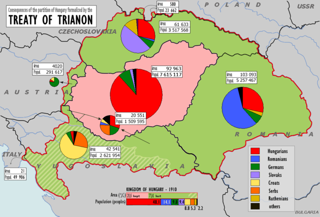
English: w:Treaty of Trianon
Magyar: A trianoni békeszerződés következményei
Slovenčina: Následky trianonskej mierovej zmluvy
Čeština: Následky trianonské mírové smlouvy
Deutsch: Friedensvertrag von Trianon
Română: Tratatul de pace de la Trianon
The graphs have been changed for better viewing convenience |
| Ημερομηνία | (UTC) |
| Πηγή | |
| Δημιουργός |
|
| άλλες εκδόσεις | Derivative works of this file: Trianon consequences.png |
| Αυτή είναι μία ρετουσαρισμένη εικόνα, που σημαίνει ότι έχει μεταβληθεί ψηφιακά από την αρχική της έκδοση. Η πρωτότυπη μπορεί να βρεθεί εδώ: Hungary1910-1920.png.
|
Αδειοδότηση
Το αρχείο διανέμεται υπό την άδεια Creative Commons Αναφορά προέλευσης-Παρόμοια διανομή 3.0 Μη εισαγόμενη
- Είστε ελεύθερος:
- να μοιραστείτε – να αντιγράψετε, διανέμετε και να μεταδώσετε το έργο
- να διασκευάσετε – να τροποποιήσετε το έργο
- Υπό τις ακόλουθες προϋποθέσεις:
- αναφορά προέλευσης – Θα πρέπει να κάνετε κατάλληλη αναφορά, να παρέχετε σύνδεσμο για την άδεια και να επισημάνετε εάν έγιναν αλλαγές. Μπορείτε να το κάνετε με οποιοδήποτε αιτιολογήσιμο λόγο, χωρίς όμως να εννοείται με οποιονδήποτε τρόπο ότι εγκρίνουν εσάς ή τη χρήση του έργου από εσάς.
- παρόμοια διανομή – Εάν αλλάξετε, τροποποιήσετε ή δημιουργήσετε πάνω στο έργο αυτό, μπορείτε να διανείμετε αυτό που θα προκύψει μόνο υπό τους όρους της ίδιας ή συμβατής άδειας με το πρωτότυπο.
Καταγραφές ανεβασμάτων πρωτότυπου αρχείου
This image is a derivative work of the following images:
- File:Hungary1910-1920.png licensed with PD-user-w
- 2008-02-16T16:08:13Z File Upload Bot (Magnus Manske) 1140x776 (139397 Bytes) {{BotMoveToCommons|en.wikipedia}} {{Information |Description={{en|Treaty of Trianon}} |Source=Transferred from [http://en.wikipedia.org en.wikipedia]; Transfer was stated to be made by [[User:Themightyquill]]. (Original text
Uploaded with derivativeFX
Ιστορικό αρχείου
Κλικάρετε σε μια ημερομηνία/ώρα για να δείτε το αρχείο όπως εμφανιζόταν εκείνη τη στιγμή.
| Ώρα/Ημερομ. | Μικρογραφία | Διαστάσεις | Χρήστης | Σχόλια | |
|---|---|---|---|---|---|
| τελευταία | 12:45, 17 Ιουνίου 2018 | | 1.140 × 774 (188 KB) | Julieta39 | Verified datas according with the original map [https://commons.wikimedia.org/wiki/File:Hungary1910-1920.png] distinguing areas and populations in each territory. Reverted my own mistakes. |
| 12:20, 17 Ιουνίου 2018 |  | 1.140 × 774 (187 KB) | Julieta39 | Uncorrupted data in today Romania's territory, according with the 1910 census and the graph. | |
| 12:04, 17 Ιουνίου 2018 |  | 1.140 × 774 (187 KB) | Julieta39 | Rgvis's comput is right. Magyars are the main group in Hungary. | |
| 09:57, 9 Απριλίου 2018 |  | 1.140 × 774 (186 KB) | Rgvis | The latest version with uncorrupted data (as per original file) | |
| 08:11, 9 Απριλίου 2018 |  | 1.140 × 774 (184 KB) | Rgvis | == {{int:filedesc}} == {{Information |Description={{be-tarask|{{w|Трыянонская мірная дамова||be-x-old}}}} {{en|w:Treaty of Trianon}} {{hu|A trianoni békeszerződés következményei}} {{sk|Následky trianonskej mierovej zmluvy}} {{cs|Následky trianonské mírové smlouvy}} {{de|Friedensvertrag von Trianon}} {{ro|Tratatul de pace de la Trianon}} The graphs have been changed for better viewing... | |
| 19:28, 1 Απριλίου 2018 |  | 1.140 × 774 (172 KB) | Julieta39 | Verified Slovakia : 661 633 Magyars | |
| 19:04, 1 Απριλίου 2018 |  | 1.140 × 774 (172 KB) | Julieta39 | 161 633 Magyars in Slovakia | |
| 18:32, 3 Δεκεμβρίου 2017 |  | 1.140 × 774 (172 KB) | Mélomène | Cosmetic | |
| 12:24, 17 Οκτωβρίου 2017 |  | 1.140 × 774 (169 KB) | MAXHO | Contrastes | |
| 05:13, 10 Οκτωβρίου 2011 |  | 1.140 × 774 (184 KB) | 123iti | my changes: 1. Medjimurje not part of croatia, 2. Original map „Hungary1910-1920“ do not say that this is population of vojvodina |
Συνδέσεις αρχείου
Τα παρακάτω λήμματα συνδέουν σε αυτό το αρχείο:
Καθολική χρήση αρχείου
Τα ακόλουθα άλλα wiki χρησιμοποιούν αυτό το αρχείο:
- Χρήση σε af.wikipedia.org
- Χρήση σε azb.wikipedia.org
- Χρήση σε az.wikipedia.org
- Χρήση σε be-tarask.wikipedia.org
- Χρήση σε be.wikipedia.org
- Χρήση σε bg.wikipedia.org
- Χρήση σε bn.wikipedia.org
- Χρήση σε br.wikipedia.org
- Χρήση σε ca.wikipedia.org
- Χρήση σε cs.wikipedia.org
- Χρήση σε cy.wikipedia.org
- Χρήση σε de.wikipedia.org
- Χρήση σε en.wikipedia.org
- Miklós Horthy
- Aftermath of World War I
- Revanchism
- Kingdom of Hungary
- Hungarian irredentism
- Portal:Hungary
- Lands of the Crown of Saint Stephen
- History of Transylvania
- Jobbik
- Hungarians in Slovakia
- Slovakization
- Hungary between the World Wars
- Hungary in World War II
- Hungarians
- Talk:Treaty of Trianon
- History of Hungary
- Hungarian occupation of Yugoslav territories
- June 1920
- Dissolution of Austria-Hungary
- User:Falcaorib/Austria-Hungary
- Χρήση σε en.wiktionary.org
- Χρήση σε eo.wikipedia.org
- Χρήση σε es.wikipedia.org
- Χρήση σε eu.wikipedia.org
- Χρήση σε fa.wikipedia.org
- Χρήση σε fr.wikipedia.org
- Χρήση σε hr.wikipedia.org
Δείτε περισσότερη καθολική χρήση αυτού του αρχείου.